More than 400 comments flooded in on the federal government's proposal to build an 8-mile-long sea wall around the Charleston peninsula.
The response from most who wrote in: We want more details.
The comments, provided to The Post and Courier through a Freedom of Information Act request, came from federal agencies, land developers, state officials, environmental groups, historic preservation groups and local homeowners living both inside and outside of the proposed wall.
A large number of respondents asked for more time for public comment, and some questioned whether there needs to be a deeper environmental review before proceeding.
While the wall may help the city with sea level rise and some extreme tidal flooding, that's not the goal of the Army Corps of Engineers study. The yet-to-be-designed barrier is only aimed at shielding the Charleston peninsula against storm surge, the potentially devastating crush of water pushed onto land by a hurricane.
The wall proposal was unveiled by the Corps of Engineers in April with an estimated price tag of $1.75 billion.
It also includes pump stations to drain some rainfall from inside the wall, a line of rocks in the harbor to break waves south of Charleston's existing Battery sea wall, and additional measures to protect, or even remove, some structures outside the wall.
Its height would be about 8 feet above the point where the city starts to flood, though the wall would be different lengths based on ground elevation.
A small group said the wall was a fool's errand, that it was unwise to try to hold back Mother Nature. But a different handful of local residents urged building the wall as quickly as possible to stem rising tides. One downtown resident wrote, "Now is the time to be decisive. Let’s act now before it is too late."
But the majority of respondents had multiple hanging questions: What will the wall look like? Will it push water into surrounding neighborhoods? Will vibrations from construction damage nearby buildings?
In all three cases, the Corps does not yet have answers.
Spokeswoman Jackie Pennoyer said an analysis on water displacement is coming in the next six months. Questions about the look of the wall and construction effects would not be answered until after the city commits to paying part of the cost.
Congress must also approve federal funding for the design phase, which is not a sure thing.
Among the most detailed and critical assessments in the public comment period, which closed June 19, came from Ron Burkhard, a retired Corps engineer who specialized in value engineering, or designing a project with the most benefit for the least cost. His experience includes working on more than 700 Corps reports during his career, most recently last year.
He saw several issues with the draft report, including: that the Corps did not lay out the costs and benefits of different wall heights; did not examine whether water might seep under the wall; and that it did not extensively address what happens if a surge wave comes over the wall.
Overtopping is a distinct possibility — the Corps has already acknowledged its chosen wall height would not have stopped the peak surges from the Category 4 Hurricane Hugo in 1989.
"The decision is, is the mayor and local sponsor going to support it?" Burkhard queried. "I’d advise them not to in the current state."

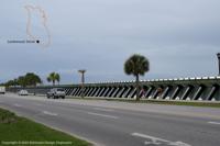
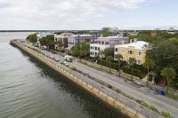
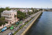
A private firm's rendering of a sea wall along Lockwood Drive. Robinson Design Engineers took pictures of existing Army Corps sea walls and placed them at locations around Charleston. The Corps has not created its own renderings. Provided/Robinson Design Engineers
The report released in April was only a draft, however. The Corps has been adjusting the path of the wall and taking other comments into consideration this summer. Pennoyer also said Burkhard retired before the Corps started doing feasibility work in its current process — an expedited timeline for studies around the country, including the one in Charleston.
The city of Charleston will release its own formal input on the plan this fall, said Mark Wilbert, the city's chief resilience officer. The team putting the city's suggestions together is led by Waggoner & Ball, the firm that was part of the Dutch Dialogues process, the city's recent collaboration with Dutch experts on flooding issues.
After that, the Corps will release an updated draft before another 30-day public comment period in January.
Environmental details
Burkhard raised questions about whether the project cost estimates were accurate, and pointed out potential problems with availability of materials, like those included in the planned breakwater.
The Corps suggests using granite for the wave break south of the city. The structure would be in the harbor about 230 feet south of The Battery, and stretch parallel to the seawall for 4,000 feet.
In total, the structure would amount to an estimated 547,086 tons of rock, according to the Corps' cost-engineering projections. That's problematic: in all of 2019, the United States produced only 440,000 tons of cut rock, according to a U.S. Geological Survey report.
Pennoyer said final decisions on project materials would not be made until engineering and design work, after congressional approval.
The breakwater was at the center of concern for several state and federal groups, including the U.S. Fish and Wildlife Service and the NOAA National Marine Fisheries Service. Both said the Army Corps needed to avoid cutting through marshes, and wanted more information on what the Corps would do to offset its marsh and fish habitat disruption.
The Environmental Protection Agency also preferred the wall be situated on high ground, and said the Corps should be sensitive to areas of different socioeconomic status, like the Rosemont and Bridgeview Village areas near the Charleston Neck, where there's proposed "non-structural" work. That could include removing homes or flood-proofing them in place.
At the center of many more technical comments was the Corp's "finding of no significant impact."
The designation is a wonky one but is also key: If there was significant impact on the environment, the Corps' proposal would go through a much longer environmental review, including a fresh look at alternatives.
The Corps said in its draft it would mitigate damage to 111 acres of wetlands elsewhere, and thus, the project will not have a significant impact. Plus, the the group has been adjusting the wall's path to reduce the amount of wetlands it would harm, said Wes Wilson, the project manager.
Some still insist on a deeper look.
"To say that this won't have a significant impact on the human environment is puzzling," said Chris DeScherer of the Southern Environmental Law Center, one of the groups pushing for a deeper review.
Pennoyer said the Corps has not received an official request from a state or federal agency to do the longer review. The Corps is updating its work to avoid natural resources, she said.
Wherever the wall winds as it loops the peninsula, on high ground or through marshes, it will encounter Charleston's history — either nearby historic buildings or even archaeological assets.
The Preservation Society of Charleston also asked for more environmental review, something that would include a deeper look at the plan's effects on cultural resources.
In addition to the wall and breakwater blocking views between the downtown historic district and sites like Fort Sumter, the Society signaled concern that heavy construction work like pile-driving could damage historic structures nearby.
The Corps would have a plan in place to monitor for damaging shaking.
Other worries
Many comments came from people and institutions outside the wall, including the S.C. Aquarium.
The main public space of the facility is above the height of the wall, part of the Corps' rationale for leaving it outside the perimeter. But several important pieces of infrastructure are not, including its nursery for injured sea turtles and machinery that supports animals in the aquarium above, CEO Kevin Mills wrote in a letter.
Aquarium employees already have to deploy temporary flood control structures used by the building when tides reach a certain height, he wrote. The Aquarium estimates that lifting its most flood-prone equipment could cost between $30 million and $50 million.
Routing around the aquarium, however, would mean putting the wall in the Cooper River and potentially impacting navigational channels, Pennoyer said.
Beyond that, several residents of the Lowndes Pointe area expressed confusion about what the wall would mean for their properties. The finger of land juts into the Ashley River's marshes on the north end of the Wagener Terrace neighborhood. It was not included inside the preliminary path for the wall.
The Corps has said gates would allow pedestrian and vehicle traffic through at several points, but those gates would be closed in case of a tropical cyclone or high tides at 8 feet or higher.
“If the walls were closed how would I access my home?" one Lowndes Pointe resident wrote. "How would I access the city if I decided to shelter in place?”
There were similar worries from residents of the Dockside Condominiums near the Aquarium, also outside the wall. The finer points on how to operate the gates would be the responsibility of the city of Charleston, should they be built, Pennoyer said.
Ultimately, one commenter worried the wall could also be a detriment to those inside it. Joshua Robinson, a hydrologist with Robinson Design Engineers, said one of his major concerns is people inside the wall being lulled into a false sense of security.
"We’ve seen this in (Hurricane) Katrina where walls provide a sense to the residents that they're safe behind the wall," Robinson said. "Those are the types of things that cause us concern."
The Link LonkAugust 23, 2020 at 09:02PM
https://ift.tt/2EmiBV4
Hundreds of comments on Charleston sea wall plan show most people want more detail - Charleston Post Courier
https://ift.tt/2CoSmg4
Sea


/cloudfront-us-east-2.images.arcpublishing.com/reuters/CZF6NULMVVMEXHOP7JK5BSPQUM.jpg)
No comments:
Post a Comment