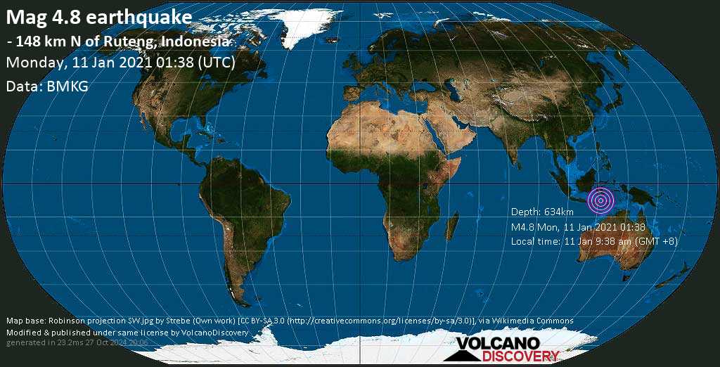
Light magnitude 4.8 earthquake at 634 km depth
11 Jan 01:45 UTC: First to report: BMKG after 6 minutes.
I felt this quake
I didn't feel it
Local time at epicenter: Monday, 11 Jan 2021 9:38 am (GMT +8)
Magnitude: 4.8
Depth: 634.0 km
Epicenter latitude / longitude: 7.57°S / 120.7°E
Nearest volcano: Ranakah (118 km / 73 mi)
Nearby towns and cities:
1537 km (955 mi) E of Jakarta (pop: 8,540,100) --> See nearby quakes!
54 km (33 mi) S of Pulau Tanahjampea Island --> See nearby quakes!
Broken Clouds
 28.8°C (84 F), humidity: 70%, wind: 1 m/s (1 kts) from S
Estimated released energy: 1 x 10¹² joules (278 megawatt hours, equivalent to 239 tons of TNT) More info

[smaller] [bigger]
Also if you did NOT feel the quake although you were in the area, please report it! Your contribution is valuable also to earthquake science and earthquake hazard analysis and mitigation efforts. You can use your device location or the map to indicate where you were during the earthquake. Thank you!
Data for the same earthquake reported by different agencies
Info: The more agencies report about the same quake and post similar data, the more confidence you can have in the data. It takes normally up to a few hours until earthquake parameters are calculated with near-optimum precision.
| Magnitude | Depth | Location | Source |
| M 4.8 | 634 km | - 148 km N of Ruteng, Indonesia | BMKG |
| M 4.8 | 636 km | FLORES SEA, Indonesia | EMSC |
| M 4.6 | 637 km | Flores Sea, Indonesia | GFZ |
| M 4.8 | 632 km | 148 Km N of Ruteng, Indonesia | USGS |
User reports for this quake
Try our free app!
Earlier earthquakes in the same area since 1900
Mag. 4.8 earthquake - Flores Sea, 54 km south of Pulau Tanahjampea Island, South Sulawesi, Indonesia, on Monday, 11 Jan 2021 9:38 am (GMT +8)-
Date / time UTC
| Mag |Depth
|Age
|Distance
| Details -
17 Jun 1996 11:22
| 7.9 |587km / 365mi
|25 years ago
|214km / 133mi
| Flores Sea (Indonesia) -
12 Dec 1992 05:29
| 7.8 |28km / 17mi
|28 years ago
|166km / 103mi
| Flores Region, Indonesia -
24 May 1990 20:09
| 7.1 |589km / 366mi
|31 years ago
|44km / 27mi
| Flores Sea (Indonesia) -
03 Mar 1927 01:05
| 7.1 |15km / 9.3mi
|94 years ago
|181km / 112mi
| Flores Sea (Indonesia) -
28 Nov 1928 10:43
| 6.9 |20km / 12.4mi
|92 years ago
|120km / 75mi
| Flores Region, Indonesia -
31 Jul 1989 17:07
| 6.8 |13.8km / 8.6mi
|31 years ago
|92km / 57mi
| Flores Region, Indonesia -
02 Aug 1992 12:03
| 6.6 |486km / 302mi
|28 years ago
|126km / 78mi
| Flores Sea (Indonesia) -
25 Mar 2003 02:53
| 6.5 |33km / 21mi
|18 years ago
|81km / 50mi
| Flores Region, Indonesia -
16 Mar 1961 13:45
| 6.5 |45km / 28mi
|60 years ago
|148km / 92mi
| Flores Region, Indonesia -
17 Aug 2018 15:35
| 6.4 |550km / 342mi
|2 years ago
|98km / 61mi
| Flores Sea -
24 Jul 1983 23:38
| 6.4 |48km / 30mi
|37 years ago
|146km / 91mi
| Flores Region, Indonesia -
23 Jan 1976 05:45
| 6.4 |614km / 382mi
|45 years ago
|88km / 55mi
| Flores Sea (Indonesia) -
13 May 1969 14:30
| 6.4 |632km / 393mi
|52 years ago
|40km / 25mi
| Flores Sea (Indonesia) -
23 Apr 1949 11:15
| 6.4 |20km / 12.4mi
|72 years ago
|24km / 15mi
| Flores Sea (Indonesia) -
09 Sep 2006 04:13
| 6.3 |572km / 355mi
|14 years ago
|76km / 47mi
| Flores Sea (Indonesia) -
21 Sep 2013 01:39
| 6.1 |537km / 334mi
|7 years ago
|88km / 55mi
| 119km NNW of Nggilat, Indonesia -
03 Jun 2008 22:04
| 6.0 |14km / 8.7mi
|13 years ago
|78km / 49mi
| Flores Region, Indonesia -
05 Sep 1984 09:32
| 6.0 |201km / 125mi
|36 years ago
|131km / 81mi
| Flores Region, Indonesia -
03 Mar 1976 22:50
| 6.0 |30km / 19mi
|45 years ago
|110km / 68mi
| Flores Region, Indonesia -
14 Jul 2020 23:33
| 5.7 |597km / 371mi
|26 weeks ago
|49km / 30mi
| Flores Sea (Indonesia) -
11 Jan 2021 01:20
| 5.5 |653km / 406mi
|4 hours ago
|24km / 15mi
| Flores Sea, Indonesia -
08 Jan 2021 16:49
| 4.8 |629km / 391mi
|3 days ago
|59km / 37mi
| Flores Sea, Indonesia -
05 Oct 2020 00:27
| 4.2 |10km / 6.2mi
|14 weeks ago
|64km / 40mi
| Flores Region, Indonesia -
22 Apr 2020 08:59
| 4.2 |17km / 10.6mi
|38 weeks ago
|57km / 35mi
| Flores Region, Indonesia -
01 Feb 2020 20:16
| 4.2 |517km / 321mi
|49 weeks ago
|66km / 41mi
| Flores Sea (Indonesia) -
23 Feb 2020 12:39
| 4.1 |358km / 222mi
|46 weeks ago
|50km / 31mi
| Flores Sea (Indonesia) -
04 Oct 2020 00:36
| 4.0 |10km / 6.2mi
|14 weeks ago
|64km / 40mi
| Flores Region, Indonesia -
07 Apr 2020 16:49
| 4.0 |27km / 17mi
|40 weeks ago
|73km / 46mi
| Flores Region, Indonesia -
28 Nov 2020 08:46
| 3.8 |498km / 309mi
|6 weeks ago
|37km / 23mi
| Flores Sea, Indonesia
Hint: Click on Date/Time to show latest first
Show all
January 11, 2021 at 08:45AM
https://ift.tt/38v9zBp
Quake info: Mag. 4.8 earthquake - Flores Sea, 54 km south of Pulau Tanahjampea Island, South Sulawesi, Indonesia, on Monday, 11 Jan 9:38 am (GMT +8) - VolcanoDiscovery
https://ift.tt/2CoSmg4
Sea
/cloudfront-us-east-2.images.arcpublishing.com/reuters/CZF6NULMVVMEXHOP7JK5BSPQUM.jpg)


No comments:
Post a Comment